How a volcano erupted without warning
Embargoed until:
Publicly released:
2022-09-01 01:00
The 2021 eruption of Mount Nyiragongo in the Democratic Republic of the Congo, which occurred with no meaningful warning, may have been triggered by a rupture in the volcano’s edifice (the conical structure), according to international scientists. They say their findings highlight the value of monitoring volcanoes, which may provide clues to how eruptions can be forecast in the absence of the usual precursory signals. Mount Nyiragongo's 2021 eruption lasted approximately six hours, and led to about 220 people reported missing or dead and 750 injured, as well as infrastructure damage. Typically, volcanic eruptions are triggered by the ascent of magma to the surface and pressure build-up, which produces detectable signals, but an edifice rupture would have meant magma was already close to the surface, leaving little time for signals to be picked up as the eruption occurred just 40 minutes later, the experts say.
Journal/conference: Nature
Research: Paper
Organisation/s: European Center for Geodynamics and Seismology, Luxemburg
Funder: Sentinel-1 SAR images and Sentinel-5P TROPOMI data are provided by
ESA. ALOS-2 SAR images are provided by JAXA under the terms and conditions of the Second
Earth Observation Research Announcement (PI No. ER2A2N086). We acknowledge S. Sobue
and Y. Aoki for assisting in the quick response of JAXA. CSK images were obtained from ASI
through the GEO GSNL Supersite initiative. We thank M. Poland, S. Ebmeier and M. Bonano for
having helped unlock the delivery of CSK images to the Virunga Supersite, and C. Tinel and
C. Proy (French Centre National d’Etude Spatiales (CNES)) for facilitating coordination between
the scientific response and space agencies participating in the United Nation (UN) ‘Space and
Major Disasters’ International Charter. TerraSAR-X SAR images were obtained from DLR
through the International Charter 'Space and Major Disasters' (© DLR e.V. 2021, Distribution
Airbus DS Geo GmbH). Pléiades images were provided by the French CNES in the frame of
DINAMIS project no. 2021 123 and ForM@Ter's CIEST2 activation. PlanetScope images were
provided through the Planets Education and Research Standard plan (ID 81527/PI:R.G. and
ID 581018/PI:BS). We thank S. Ebmeier for facilitating access to ICEYE satellite imagery. We thank
the Capella company for rapid tasking. L. Clarisse and N. Clerbaux helped obtain SEVIRI data
provided by EUMETSAT. GNSS and seismic data were provided by the KivuSnet and KivuGnet
monitoring networks maintained by European Center for Geodynamics and Seismology/
Musée National d’Histoire Naturelle (MNHN Luxembourg), the Royal Museum for Central
Africa, the Goma Volcano Observatory, the Centre de Recherche en Sciences Naturelles de Lwiro,
the Université Officielle de Bukavu, the Rwanda Petroleum and Mining Board (RMB) and the
University of Bujumbura (Burundi). The Congolese Institute for Nature Preservation,
MONUSCO and GVO staff provide support to ensure the security of these stations.
The permanent ground-based monitoring infrastructures and the contributions from B.S.,
C.M. and J.B. benefited from several past and ongoing research projects funded by the STEREOIII
Programme of the Belgian Science Policy Office, the Fonds National de la Recherche of
Luxembourg and the Belgian Directorate General for Development Cooperation and
humanitarian aid, a.o. RESIST (SR/00/305 and INTER/STEREOIII/13/05), VeRSUS (SR/00/382)
and HARISSA. RMB assisted the deployment of the temporary seismic stations. Airborne
campaigns were made possible with the support of MONUSCO. J. L. Froger and Y. Fukushima
provided the unwrapping algorithm used for S1 interferograms. Y. Morishita, P. Lundgren and
F. Delgado helped improve the processing and ionospheric corrections of the ALOS-2
interferograms. Deformation modelling benefited from the infrastructure and assistance of the
Mésocentre from the University of Clermont Auvergne, from funds from French Government
Laboratory of Excellence initiative no. ANR-10-LABX-0006. This is Laboratory of Excellence
ClerVolc contribution no. 548. This work is a contribution to the EUROVOLC project, under the
EU Horizon 2020 and Innovation Action, grant no. 731070. S.P. was supported by a FRS-FNRS
postdoctoral fellowship at Université libre de Bruxelles . C.W. acknowledges funding by the
National Science Foundation (grant no. EAR 1923943).
Media release
From: Springer Nature
How a volcano erupts without warning
The 2021 eruption of Mount Nyiragongo in the Democratic Republic of the Congo, which occurred with no meaningful warning, may have been triggered by a rupture in the volcano’s edifice (the conical structure), a paper published in Nature suggests. The findings highlight the value of monitoring volcanoes, which may provide clues to how eruptions can be forecast in the absence of the usual precursory signals.
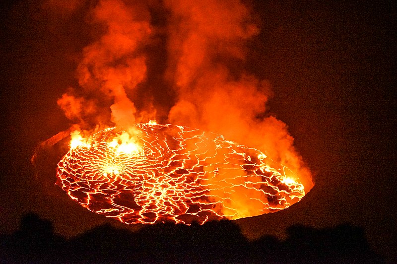
Mount Nyiragongo is an open-vent volcano with a large lava lake housed in the summit crater. Its eruption in May 2021 lasted approximately six hours, producing lava flows that led to about 220 people reported missing or dead and 750 injured, as well as infrastructure damage. The eruption appeared to have occurred without any precursors that could have provided a warning. Typically, volcanic eruptions are triggered by the ascent of magma to the surface and pressure build-up, which produces signals that can be detected. Two historical eruptions of Mount Nyiragongo, in 1977 and 2002, did have precursors, with seismic activity and eruptive activity reported before the main eruptions.
Delphine Smittarello and colleagues analysed the May 2021 eruption of Mount Nyiragongo and suggest that the eruption may have been triggered by an edifice rupture, which may have occurred because stress reached tensile strength (the maximum stress it could take before rupturing) or the structure weakened over time as a result of sustained stress and high temperatures. As the magma was already close to the surface and only had to travel a short distance before erupting, this left little time to detect the signals before the eruption 40 minutes later.
The authors note that these findings raise questions about the mechanisms behind Mount Nyiragongo’s eruptions and the possibility of more hazardous events due to its proximity to populated areas. More generally, they argue it highlights the issues raised by open-vent volcanoes for monitoring, early detection and risk management.
Attachments:
Note: Not all attachments are visible to the general public


