
EXPERT REACTION: Hurricane Florence
Organisation/s: Australian Science Media Centre
Attachments:
Note: Not all attachments are visible to the general public

News for:
Australia
Multimedia:
-
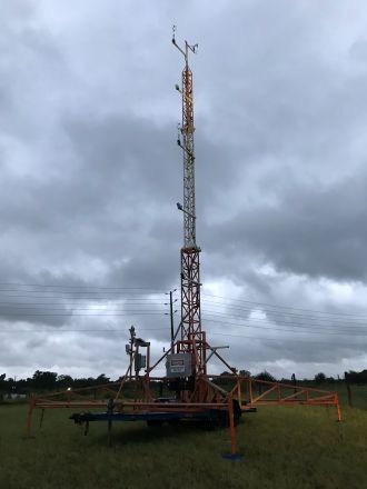 Mobile weather stations
Mobile weather stations setup in the US to detect cyclones. They are the similar to the SWIRLnet cyclone deployment program run at JCU (jcu.edu.au/swirlnet). The data from these towers (FCMP 1, 2, and 3, shown as yellow 36, 34, 28 in the “Capture.png”) can be viewed live at the following link: http://ds.weatherflow.com/storm/florence#34.438,-76.381,9,8,1026,1
File size: 6.3 MB
Attribution: Daniel Smith
Permission category: © - Only use with this story
Last modified: 20 May 2021 4:12pm
NOTE: High resolution files can only be downloaded here by registered journalists who are logged in.
Media contact details for this story are only visible to registered journalists.
Expert Reaction
These comments have been collated by the Science Media Centre to provide a variety of expert perspectives on this issue. Feel free to use these quotes in your stories. Views expressed are the personal opinions of the experts named. They do not represent the views of the SMC or any other organisation unless specifically stated.