
 Australia; NSW
News release
From:
From southbound cane toads to invasive weeds and fluctuating fish stocks, a novel technique called eDNA has revealed what’s in NSW waterways - and how it's influenced by natural disasters.
The major study of NSW estuaries, led by Southern Cross University and funded through the Riparian Stabilisation Package of the NSW Estuary Asset Protection (NEAP) Program, has created the first biodiversity map of major river mouths and coastal tributaries along a 1,000 kilometre stretch of coastline, using a novel technique called eDNA.
Environmental DNA, or eDNA, is similar to the technology employed to detect COVID fragments in wastewater during the COVID-19 pandemic. This highly sensitive technology is being increasingly used around the world to identify the origins of organic material, from algae blooms in lakes to critically endangered species in the ocean.
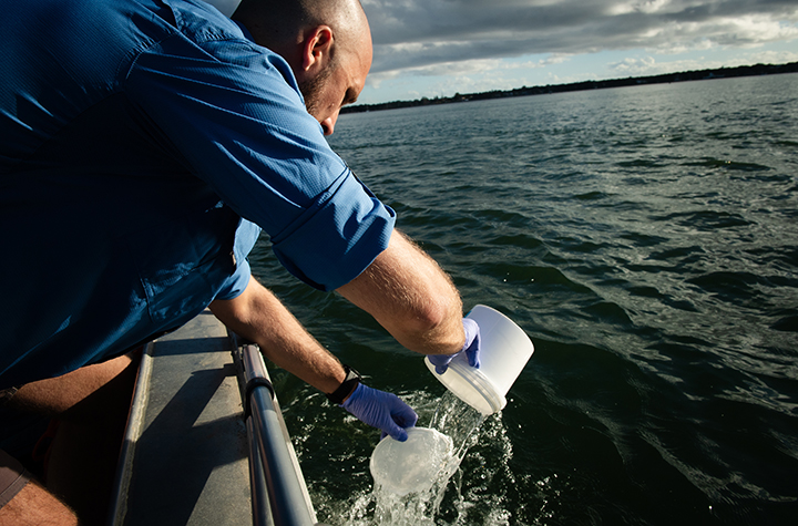
It relies on discarded genetic material in the environment, such as scales, faeces, fur or skin.
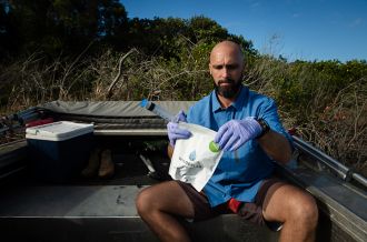
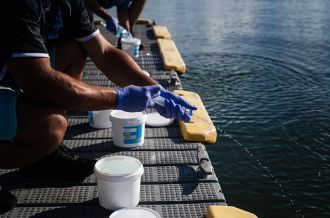
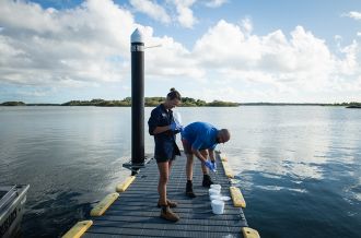
Southern Cross researchers, in collaboration with colleagues from the NSW Department of Primary Industries and Regional Development (DPIRD) and with assistance from local Indigenous ranger networks, collected samples from more than 33 estuaries along the NSW coastline on 234 separate sites, in both summer and winter.
They used a particular technique known as eDNA metabarcoding. This technique samples for many species at the same time, by extracting DNA from water or sediment. The short DNA sequences extracted (barcodes) are then mapped to reference databases.
Lead investigator Dr Maarten De Brauwer of Southern Cross University said the data paints a fascinating picture of the species living in and around NSW coastal tributaries, including birds, worms, plants, fish, sharks and invasive pests.
“The data revealed the location of 68 invasive pest species in various rivers, including aquatic weeds, algae and even cane toads further south than previously thought.”
Dr De Brauwer said the project, part of the NEAP program developed after the 2022 floods, provided much-needed baseline data for managing critical ecosystems.
“This data can show what is actually happening to our biodiversity in estuaries following disasters like floods and bushfires. This can inform management agencies, biosecurity responses and help the ranger network manage these complex and dynamic systems after major disasters to support species recovery,” he said.
This baseline is already being put to the test. Dr De Brauwer’s team recently returned to sample sites following Tropical Cyclone Alfred and the extreme rain events of March 2025 to compare data.
This will be a valuable addition to the current mapping which includes more than 7,000 species. This data is available as an interactive map on the publicly available site of the lab that completed the DNA analysis, Wilderlab: https://wilderlab.co/explore
Some of the sample sites produced surprising results.
“While the collection method is simple, the technology is incredibly sensitive and some of our results required some sleuthing,” said Dr de Brauwer.
“For example, we found water buffalo DNA in the Richmond River, very far from where you would expect to find it. When we went to look for the source, we found a horse trainer along the river was using four water buffaloes named Bob, Ben, Bill and Bruce to train horses, which explained it!”
Where water quality is poor, for example in post-flood or post-cyclone conditions, the technique can offer a quick and cheap solution.
DPIRD Fisheries Technician Kait Harris said estuaries – the middle ground between the ocean and rivers – do not have recent state-wide biodiversity baselines.
“This data is very valuable to understand how we manage them, particularly in challenging circumstances like natural disasters.
“When we are sampling, people are really interested in what we are doing. Fishers, boaties and everyone in the community use estuaries for recreational fishing, swimming, or even work. It’s a very visible ecosystem that can be heavily impacted by natural disasters,” she said.
Indigenous ranger groups have been important partners in the project said Dr De Brauwer, helping to collect samples and also contributing local knowledge about the sample sites.
The Riparian Stabilisation Package of the NSW Estuary Asset Protection Program is jointly funded by the Australian Government and NSW Government under the Disaster Recovery Funding Arrangements.
Southern Cross University is a leader in river and estuarine monitoring under the Catchments, Coasts and Communities Research Impact Cluster. Learn more: scu.edu.au/research
How to access the map of results
Go to https://www.wilderlab.co.nz/explore and click on the "Filter" tab. Type in "NEAP" in the "Search by sample/job number" box. This will show only project results. You can also search by species, for example, "Search by sample/job number": NEAP + Search by species/taxon: "seal", shows you all sites where the project team detected seals.
Rivers surveyed:
Northern NSW
- Tweed River
- Brunswick River
- Tallow Creek
- Richmond River
- Clarence River
- Sandon River
- Woolgoolga Lake
- Moonee Creek
- Coffs Creek
- Bellinger River
- Macleay River
- Hastings River
Central NSW
- Manning River
- Wallis Lake
- Port Stephens
- Hunter River
- Lake Macquarie
- Hawkesbury River
- Manly Lagoon
- Botany Bay
- Port Hacking
- Lake Illawara
- Spring Creek
Southern NSW
- Shoalhaven River
- St Georges Basin
- Meroo Lake
- Clyde River
- Wagonga Inlet
- Tilba Tilba Lake
- Wallaga Lake
- Bega River
- Merimbula Lake
- Curalo Lagoon
- Wonboyn River
Multimedia
Attachments
Note: Not all attachments are visible to the general public. Research URLs will go live after the embargo ends.


