
 Australia; NSW; VIC; QLD; NT
News release
From:
Expert Reaction
These comments have been collated by the Science Media Centre to provide a variety of expert perspectives on this issue. Feel free to use these quotes in your stories. Views expressed are the personal opinions of the experts named. They do not represent the views of the SMC or any other organisation unless specifically stated.
Dr Ali Hadigheh is a lecturer at the School of Civil Engineering at the University of Sydney
In recent years, Australia has experienced a number of large scale and devastating natural disasters including major flooding and damaging storms such as cyclones. If we look at statistics, Australia has experienced at least one major cyclone in every three to four years.
It seems these natural disasters are inevitable nowadays, so we need to think about how we can minimise the impact of these events.
Frequency and intensity of these cyclones have put an increasing pressure on Australian infrastructures. For example, in an event like a cyclone, the community heavily relies on road networks in the region.
In regions such as the Gulf of Carpentaria, where towns are stretched along the coast and geographically are far apart from each other, roads play a vital part in the economy as well as reducing the vulnerability of the community before, during and after an event.
The risk from natural hazards in some cases can be understood in a such a way that we can minimize the hazard to humans, and thus minimise the risk. To do this, we need to understand something about the processes that operate, and understand the energy required for the process. Then, we can develop actions to take to minimise the risk. Such minimisation or elimination of risk is called hazard mitigation.
There are factors that lead to vulnerability of a community to natural hazards, such as a lack of understanding, education, infrastructure, increased population density, and lack of communication.
Research found that disasters mostly affect the most disadvantaged local government areas, for instance in NSW, almost 50 per cent. This demonstrates the role that social disadvantage plays in influencing susceptibility to disasters. The key message for our area is that we need to deal with social disadvantage causes.
It is the responsibility of all of us;
• Government: how to put proper legislation in place and educate people
• Community: to promote awareness and locally manage and mitigate vulnerabilities
• Individuals: Know the hazards in your area, know your vulnerabilities, and know your risk
Lack of knowledge of these vulnerabilities makes it difficult to make appropriate emergency management plans, which are necessary in order to be prepared and enable the community to resume functionality as soon as possible after the event.
Our research at the University of Sydney helps to achieve this goal by the development an integrated framework for assessing the disaster-resilience of infrastructure by optimising strengthening techniques.

Mr Bruce Gunn is the Queensland State Manager at the Bureau of Meteorology (BoM)
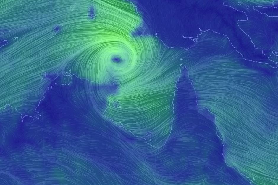
Overnight conditions in the Arafura Sea were optimal for cyclone development and the tropical low intensified to Category 1 strength around 04:00 this morning.
Conditions remain favourable for Cyclone Nora to further intensify to severe Category 3 strength today or tomorrow as it tracks in a south-easterly direction.
The immediate impacts are gale-force winds for the warning areas and possible coastal inundation of low-lying areas.
While cyclones in the Gulf can be more unpredictable, the forecast is firming up for Cyclone Nora to approach the south-eastern Gulf coast, before turning back towards the Northern Territory border.
As Cyclone Nora moves closer to the eastern Gulf coast, abnormally high tides between the Torres Strait and Karumba and large waves on the coast are possible.
There is also the potential for very heavy rainfall and further flooding of catchments in the Gulf and east coast north of Townsville as the cyclone's influence broadens, drawing in moisture from surrounding coastal waters. Many catchments are already saturated from recent flooding, and renewed river level rises and isolation due to flood waters are a reality affected communities will need to prepare for again.
Dr John Bates is Research Director at the Bushfire and Natural Hazards Cooperative Research Centre
For communities in Nora’s watch area, the time to enact your cyclone plan is now. There is nothing more important than your safety and the safety of your family - listen to the advice of the emergency services and the Bureau of Meteorology.
Ensure your home is secure, and don’t forget about securing the little things around your home, like outdoor furniture. Research shows that these items can cause a lot of damage to homes; damage that can sometimes have been prevented.
Dr David Henderson is the Chief Engineer at the Cyclone Testing Station in James Cook University (JCU)
The current Bureau of Meteorology prediction of path and intensity indicates that wind speeds along the Peninsular and Gulf coast are hopefully likely to be lower than the current building design levels for homes built since the 80’s. However, our past experience indicates that wind-borne debris can cause damage to any buildings.
It is really important that people have cleaned up any loose items that could be picked up by the wind. There is still time for communities near the predicted path to secure loose items and remove shade sails etc.
During recent tropical cyclones in both WA and QLD, significant volumes of water have been blown into undamaged houses, and the CTS is currently working on ways of reducing the volume of rain water that comes into houses in tropical cyclones.
This water comes through small gaps on the windward side of the building, and in the past, people have tried to mop it up as it comes in. However, it is really dangerous to be in front of large windows in a tropical cyclone, because wind-borne debris can break them, with the potential for serious injury.
The best strategy is to follow QFES recommendations. The potentially impacted communities need to heed the advice of the local councils and emergency services with regard to possible Storm Surge impacts.
