
 Australia; NSW; VIC; QLD; ACT
News release
From:
Expert Reaction
These comments have been collated by the Science Media Centre to provide a variety of expert perspectives on this issue. Feel free to use these quotes in your stories. Views expressed are the personal opinions of the experts named. They do not represent the views of the SMC or any other organisation unless specifically stated.
Dr Tom Hubble is an Associate Professor of Engineering and Environmental Geology at The University of Sydney
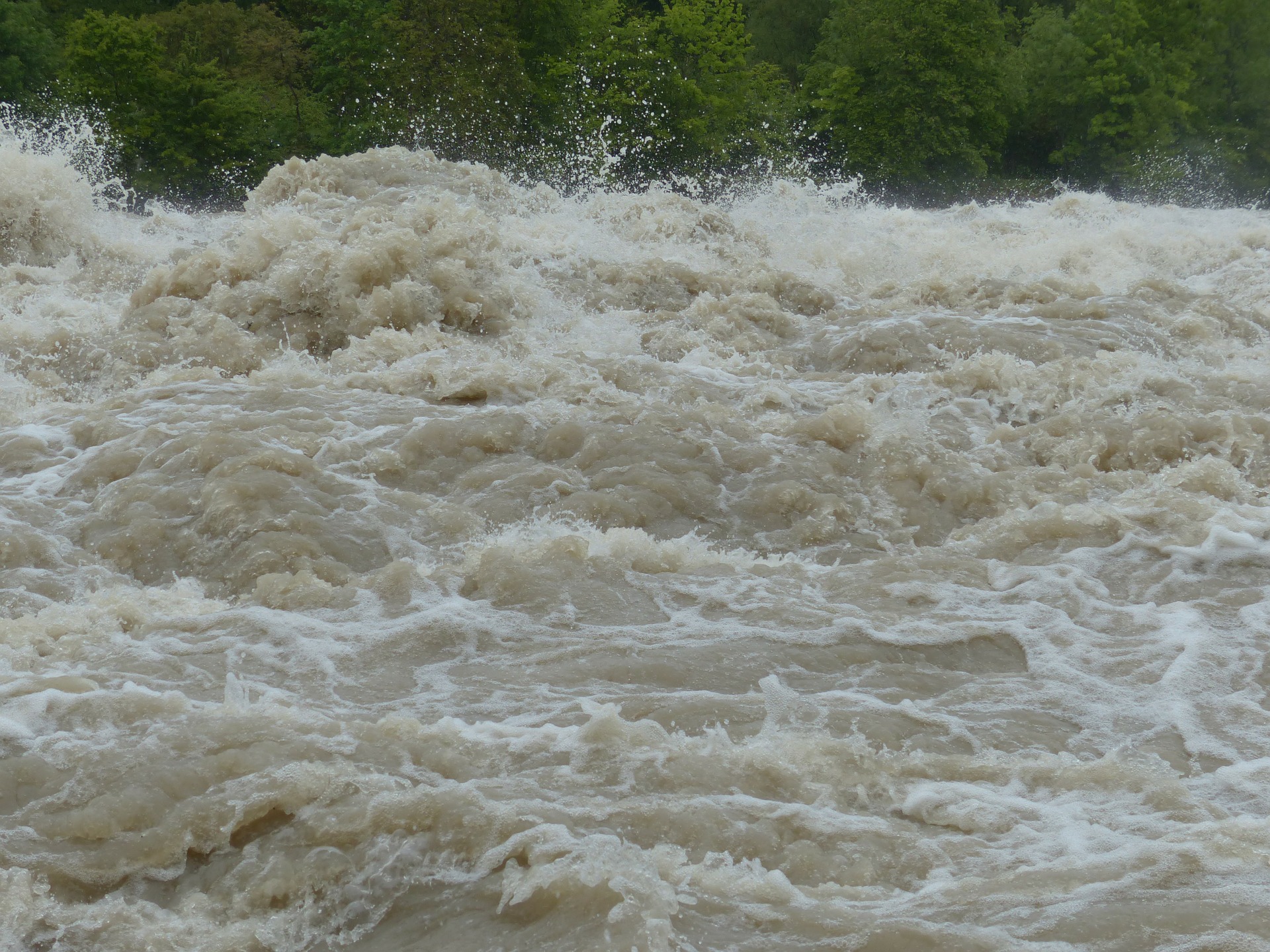
One factor that has contributed to the large volume of floodwater flowing through the Hawkesbury-Nepean River and affecting the river stretch between Penrith and Sackville is the so-called ‘Bathtub Effect’.
This ‘bathtub’ is a low-lying natural basin-like depression in the landscape that has formed very slowly over the past 100 million years due to plate tectonic processes associated with the formation of the Tasman Sea. ‘The Bathtub’ is floored by layers of mudstone rock that have been folded into a basin-shaped depression. This geological structure is surrounded by the steep terrain and deep gorges eroded into the Sydney sandstones of the Blue Mountains and the Hawkesbury River.
At the transition between the bathtub’s mudstones and the gorges of the surrounding high-standing sandstone country the Hawkesbury-Nepean River’s channel narrows in width. This creates a pinch-point constriction that partially blocks the river channel and impedes the river flow. In the same way that a bathplug sitting halfway over a plughole slows down the draining of a bath, this natural pinch-point structure has backed-up floodwaters into the ‘Bathtub’.

Dr Margaret Cook is a History Lecturer at the University of the Sunshine Coast (USC)
Historically, cities throughout the world have been built on floodplains as they provide a water source, transportation, and in earlier times, fuel and effluent dumps. Riverside land is an attractive place to build homes.
Australia has two dominant hydrological cycles - flood and drought. During floods we are made aware of our flood vulnerability. Floodwaters expose the floodplain, land that seems incapable of flooding in drought. Dry years confuse our environmental knowledge as floods are relegated to memory. We develop a myth that they won’t happen again. We confuse the idea that a one in 100-year flood means it won’t happen again for another 100 years – not what this means. We build dams or engineering structures that convince us they won’t happen again.
Often there are decades between floods and newcomers to the region don’t have the knowledge of previous floods to help them understand the risk and the need to evacuate. Knowledge and memory saves lives and property. Those who have experienced previous floods know to evacuate.
It is vital that as our cities grow, we do not become complacent about floods; raise dam walls or levee banks thinking we are safe and then encroach further on to the floodplain. Floods will come again. They might be bigger than those experienced before. We need to respect our rivers and learn to adapt to Australia’s hydrological cycles.
Dr Richard Thornton is CEO of the Bushfire and Natural Hazards CRC.
We know that many people underestimate the risk floodwaters pose, especially when it comes to driving. Research has shown how difficult it can be to accurately assess the depth of water on a road, even on roads we are familiar with. It is almost impossible to see any damage to the road surface beneath the water - and still or slow-moving floodwater is extremely dangerous. Research has also shown that people often take their cues from the actions of those around them. So, if some are taking risks, that encourages others to do the same. Drivers on the roads should take heed of the official emergency warning messages about what is safe, and what is not, not the actions of others.
How we live and work in potentially risky areas is rightly at the front of the discussions. With climate projections showing that extreme weather events are becoming more likely, the research is looking at what this means for building new homes and infrastructure, and for protecting what is already there.
We need to ensure that we do not increase the future risk by the decisions we are currently making, particularly when that risk profile is shifting as the climate and demographics of our communities are also changing. This is why we need new knowledge and research to help inform decision-makers and communities.
Professor Todd Lane is from the School of Earth Sciences at The University of Melbourne
This is a significant event, linked to the easterly wind flow transporting moisture from the Tasman Sea, which is interacting with inland troughs to produce large rainfall totals. It is unusual in terms of rainfall accumulations, but we should be cautious about linking this event to climate change. There is still much uncertainty about future rainfall in the NSW region and climate models show limited agreement in projected rainfall and extreme rainfall trends. Importantly, little is known about how the frequency of weather events like this one will change with global warming. What we do know is that in a warmer world the atmosphere can hold more moisture, so as the climate continues to warm events like this have the potential to produce more rain when they occur.
Dr Tom Mortlock is Head of Climate Analytics Asia-Pacific at Aon, and Adjunct Fellow in the Climate Change Research Centre at UNSW
This is the first significant flood event for NSW since the flooding experienced during the February 2020 East Coast Low. This time, the background situation is very different, making this a much more dangerous event.
First, present flooding is being caused by a widespread and stationary low pressure trough extending the whole of the NSW coast, making this a multi-day flood event across the state; in February 2020, the cause was a more transient low pressure cell.
Second, this event comes on the back of a La Niña summer, meaning most catchments are already wet with low infiltration capacity, and dams are already at high levels. As a result, dam spillage around the Sydney catchments has contributed to flooding in the Hawkesbury-Nepean areas. By comparison, the February 2020 event came on the back of an exceptionally dry period with dams at record low levels.
This summer has primed NSW catchments for high flood risk, with this event coming at the end of a wetter-than-average summer, and really highlights the importance of year-on-year climate variability for flooding along the east coast.
Professor Jamie Pittock is from the Fenner School of Environment and Society at The Australian National University
The impact of the floods in the Hawkesbury – Nepean valley is due to poor governance rather than any act of God. Extreme floods have been recorded in the valley since the earliest years of British occupation over two centuries ago. And now climate change is likely to increase the frequency of dangerous floods.
Successive state governments have failed to address the 5,000 homes built below the 1:100 year flood line. The NSW Government’s proposed ‘silver bullet’ solution of raising the Warragamba Dam to control floods is dangerous. International experience is that such infrastructure encourages more downstream development that is then inundated when the inevitable big flood exceeds design limits. Further, the dam will not regulate floodwaters from downstream tributaries like the Grose River and South Creek.
Raising the dam would also inundate part of the Blue Mountains World Heritage Area, threatened species populations and cultural sites of the Gundangara nation.
The NSW Government should stop plans for 134,000 people to move onto the floodplain by 2050. It should begin long term programs to help the most flood-prone residents relocate to safe sites. Restoring the floodplain to give the river room to flood more safely can boost opportunities for agriculture, recreation and nature conservation.
