
 International
News release
From:
Scientists discover new penguin colony from space
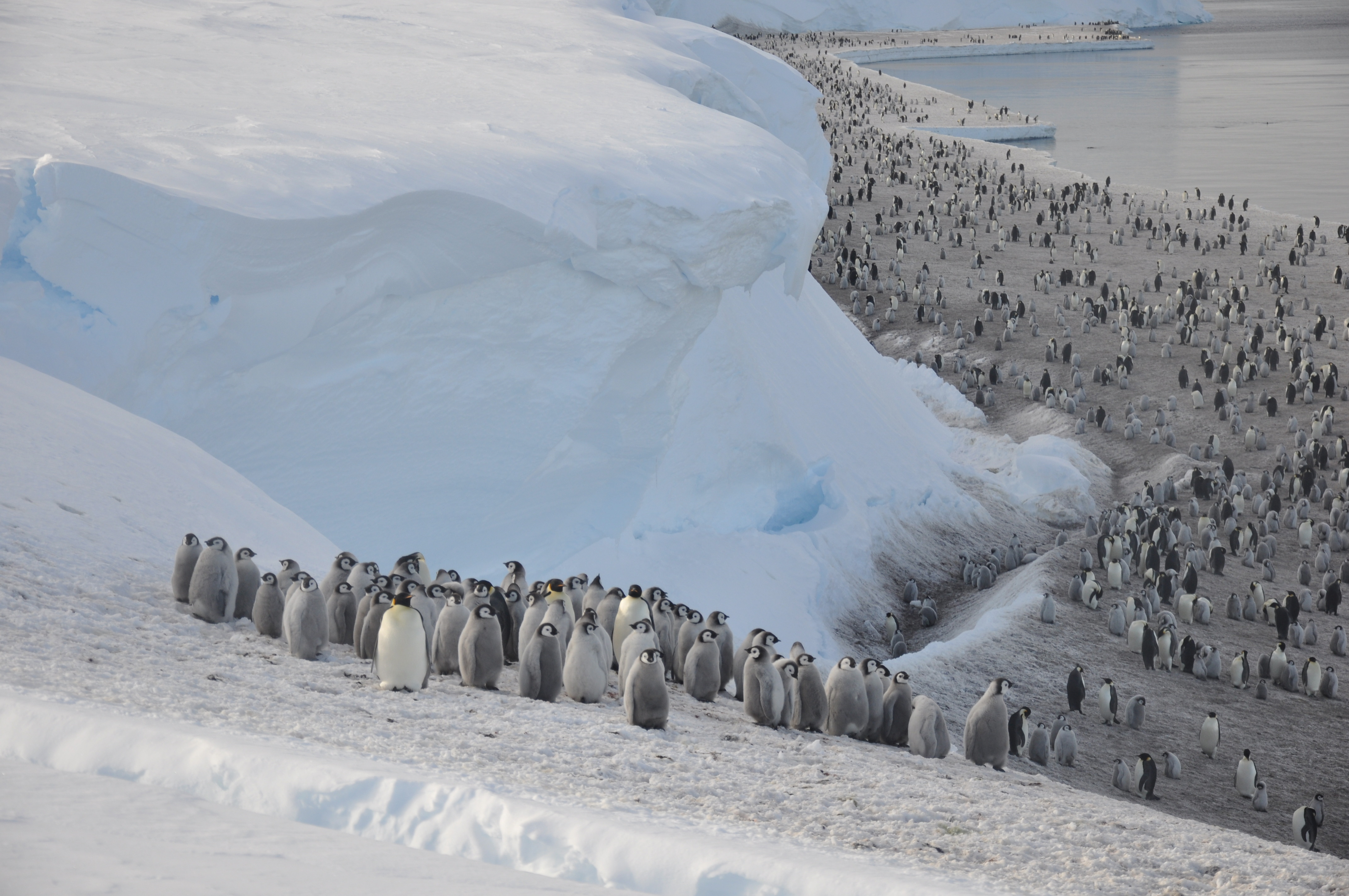
Scientists have discovered a new emperor penguin colony in Antarctica using satellite mapping technology. This new colony makes a total of 66 known emperor penguin colonies around the coastline of Antarctica, with exactly half having been discovered by satellite imagery.
The team studied images from the European Commission’s Copernicus Sentinel-2 satellite mission which were compared to and confirmed by high resolution images from the MAXAR WorldView3 satellite. The team identified the colony from the penguin guano stains, which are brown in colour and easier to identify alongside the ice and rock. The new site, at Verleger Point West Antarctica, houses around 500 birds and is located at 74° 42’ S, 136° 11’W.
Emperor penguins need sea ice to breed and are located in areas that are very difficult to study because they are remote and often inaccessible and can experience temperatures as low as −60°C (−76°F). For the last 15 years, British Antarctic Survey (BAS) scientists have been looking for new colonies by searching satellite imagery for their guano stains on the ice.
Lead author Dr Peter Fretwell, who studies wildlife from space at BAS says:
“This is an exciting discovery. The new satellite images of Antarctica’s coastline have enabled us to find many new colonies. And whilst this is good news, like many of the recently discovered sites, this colony is small and in a region badly affected by recent sea ice loss”.
Emperor penguins are known to be vulnerable to loss of sea ice, their favoured breeding habitat. With current projections of climate change, this habitat is likely to decline the most recent projects suggest that, under current warming trends, 80% of colonies will be quasi-extinct by the end of the century.
The research was funded by UKRI-NERC as part of the Wildlife from Space project with a contribution from WWF.
Notes to Editors:
Satellite images and still images plus video of Emperor penguins can be found here: https://files.bas.ac.uk/photo/emperor_penguins/
Please ensure the satellite image of the Verleger Point colony of Emperor penguins is credited to MAXAR technologies 2023.
Copernicus Sentinel-2 is one of the satellite missions that ESA (European Space Agency) develops and operates on behalf of the European Commission’s Copernicus environmental monitoring programme. Copernicus Sentinel-2 comprises two satellites (A&B). ESA undertakes high frequency data collection around the margins of the continent, with data collected in 2016, 2018 and 2019. Images collected are higher resolution than previous Landsat data images. Sentinel-2 has been collecting images of Antarctica since 2016 following the request from SCAR, the Scientific Committee on Antarctic Research.
MAXAR Technologies is a commercial satellite provider. This image is a 30 cm resolution WorldView3 image of the site dated 8 October 2021.
British Antarctic Survey (BAS) delivers and enables world-leading interdisciplinary research in the Polar Regions. Its skilled science and support staff based in Cambridge, Antarctica and the Arctic, work together to deliver research that uses the Polar Regions to advance our understanding of Earth as a sustainable planet. Through its extensive logistic capability and know how BAS facilitates access for the British and international science community to carry out research in the Polar Regions. Numerous national and international collaborations, combined with an excellent infrastructure, help sustain a world leading position for the UK in Antarctic affairs.
British Antarctic Survey is a component of the Natural Environment Research Council (NERC). NERC is part of UK Research and Innovation www.ukri.org
For more information visit www.bas.ac.uk @basnews
Attachments
Note: Not all attachments are visible to the general public. Research URLs will go live after the embargo ends.


