Over 100,000km more roads lead to Rome

Publicly released:
International
Ox carts or pack animals transported food over roads that connected the farms where it was produced to the cities where it would be traded or consumed. Credit: Itiner-e, Artas Media, MINERVA.

If all roads lead to Rome, those roads are 100,000km longer according to international researchers, who have built a digital map of roads throughout the Roman Empire at around 150 CE. The team used archaeological and historical records, topographic maps, and satellite imagery to build the Itiner-e map, which found 299,171 kilometers of roads — an increase from a previous estimate of 188,555 kilometres — covering almost four million square kilometres. The authors suggest that Itiner-e represents the most detailed and comprehensive openly accessible digitisation of the Empire’s roads and that it also highlights gaps in current knowledge of the road system.

Media release

From: Springer Nature

Archaeology: Digital map increases Roman Empire road network by 100,000 kilometres 

A new high-resolution digital dataset and map — named Itiner-e — of roads throughout the Roman Empire around the year 150 CE is presented in research published in Scientific Data. The findings increase the known length of the Empire’s road system by over 100,000 kilometres.

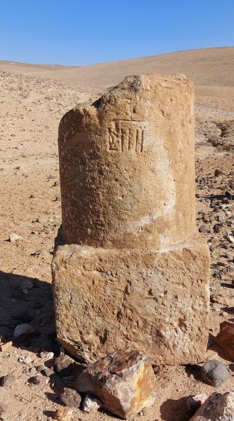
At its height in the second century CE, the Roman Empire included over 55 million people and stretched from modern day Britain to Egypt and Syria. Although a network of roads throughout the Empire facilitated its development and maintenance, it remains incompletely mapped and existing digitisations are low resolution.

Tom Brughmans, Pau de Soto and Adam Pažout and colleagues created Itiner-e using archaeological and historical records, topographic maps, and satellite imagery.

The dataset includes 299,171 kilometres of roads — an increase from a previous estimate of 188,555 kilometres — covering almost four million square kilometres. The authors attribute this increase in road coverage to higher coverage of roads in the Iberian Peninsula, Greece and North Africa and to the adapting of previously proposed road routes to fit geographical realities. This includes allowing roads crossing mountains to follow winding paths rather than direct lines. Itiner-e comprises 14,769 road sections, with 103,478 kilometres (34.6%) classified as main roads and 195,693 kilometres (65.4%) as secondary roads. The authors report that the precise locations of only 2.7% of the roads are known with certainty, while 89.8% are less precisely known, and 7.4% are hypothesised.

The authors suggest that Itiner-e represents the most detailed and comprehensive openly accessible digitisation of the Empire’s roads and that it also highlights gaps in current knowledge of the road system. They note that Itiner-e cannot show changes in the road system over time and that future research is needed to investigate this throughout the Empire. They propose that Itiner-e could be used in future research investigating the influence of Roman roads on connectivity, administration, migration, and disease transmission in the Empire.

Multimedia

Fragment of a Roman milestone
The Roman road network created by Itiner-e
The Roman roads through mountain passes leading to Delphi
A walking journey from Delphi to Athens during the Roman Empire
An 8 minute animation movie

Attachments

Note: Not all attachments are visible to the general public. Research URLs will go live after the embargo ends.

Other Springer Nature, Web page The Itiner-e open dataset and map
Journal/
conference:
Scientific Data
Research:Paper
Organisation/s: Universitat Autònoma de Barcelona, Spain
Funder: This work was supported by Danmarks Frie Forskningsfond (DFF) Sapere Aude research leadership grant (0163-00060B) awarded to T.B. for project MINERVA; the Carlsberg Foundation’s Young Researcher Fellowship (CF21-0382) awarded to T.B. for The Past Social Networks Project; Danish National Research Foundation (DNRF) Centre of Excellence for Urban Network Evolutions (UrbNet) (DNRF119); and the Viator-e project RTI2018-098905-J-I00 funded by MCIN/AEI/10.13039/501100011033/ and by FEDER, una manera de hacer Europa awarded to P.S. We would also like to sincerely thank the many other non-author contributors who have accompanied us during the difficult (but rewarding) process of Roman road digitisation.
Media Contact/s
Contact details are only visible to registered journalists.