International
News release
From:
WMO certifies megaflash lightning record in USA
- Longest single lightning flash of 829 km in USA in 2017 sets new record
- Advanced satellite technology enables better monitoring
- Previous record was also in US Great Plains - a storm hotspot
- Lightning is major hazard and priority for Early Warnings For All
*WMO Weather and Climate Extremes Archive maintains official records
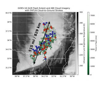
The World Meteorological Organization (WMO) has established a new world record for the longest lightning flash – an incredible 829 km (515 miles) in a notorious storm hotspot in the United States of America.
The megaflash occurred in October 2017, during a major thunderstorm complex. It extended from eastern Texas to near Kansas City - equivalent to the distance between Paris and Venice in Europe. It would take a car about eight to nine hours and a commercial plane at least 90 minutes to cover that distance.
“Lightning is a source of wonder but also a major hazard that claims many lives around the world every year and is therefore one of the priorities for the international Early Warnings for All initiative. These new findings highlight important public safety concerns about electrified clouds which can produce flashes which travel extremely large distances and have a major impact on the aviation sector and can spark wildfires,” said WMO Secretary-General Celeste Saulo.
WMO’s Committee on Weather and Climate Extremes, which maintains official records of global, hemispheric and regional extremes, recognized the new record with the help of the latest satellite technologies. The findings were published in the Bulletin of the American Meteorological Society.
There is a margin of error of ± 8 km (5 mi) in the new record of 829 km (515 miles). It is 61 kilometrers greater than the previous record, which covered a distance of 768 ± 8 km (477.2 ± 5 miles) across parts of the southern United States on 29 April 2020.
The new record lightning flash occurred in one of the hotspots for Mesoscale Convective System (MCS) thunderstorms, whose dynamics permit extraordinary megaflashes to occur – namely, the Great Plains in North America.
Both the previous and new record used the same maximum great circle distance methodology to measure flash extent. The 2017 event is notable in that it was one of the first storms where NOAA’s newest Geostationary Operational Environmental Satellite (GOES-16) documented lightning ‘megaflashes‘ – extremely long duration/distance lightning discharge events.
This particular flash was not identified in the original 2017 analysis of the storm but was discovered through a re-examinaton of the thunderstorm.
“This new record clearly demonstrates the incredible power of the natural environment. Additionally, WMO assessment of environmental extremes such as this lightning distance record testify to the significant scientific progress in observing, documenting and evaluating such events. It is likely that even greater extremes still exist, and that we will be able to observe them as additional high-quality lightning measurements accumulate over time,” said Professor Randall Cerveny, rapporteur of Weather and Climate Extremes for WMO.
The WMO Archive of Weather and Climate Extremes maintains official records of the world, hemispheric and regional extreme records associated with a number of specific types of weather. Presently, the Archive lists extremes for temperature, pressure, rainfall, hail, wind, and lightning as well as two specific types of storms, tornadoes and tropical cyclones.
Other previously accepted WMO lightning extremes are:
*The greatest duration for a single lightning flash of 17.102 ± 0.002 seconds during a thunderstorm over Uruguay and northern Argentina on 18 June 2020.
*Direct strike: 21 people killed by a single flash of lightning as they huddled for safety in a hut in Zimbabwe in 1975.
*Indirect strike: 469 people killed in Dronka Egypt when lightning struck a set of oil tanks, causing burning oil to flood the town in 1994.
“Investigation of megaflashes is providing new insights into the mesoscale electrical charge variations in Mesoscale Convective System thunderstorms. Furthermore, it illustrates the threat of the newly recognized “bolt from the gray,” analogous to the “bolt from the blue” from isolated cells, but one that can travel many hundreds of kilometers from the main charge generating region,” said lightning specialist and committee member Walt Lyons.
“The only lightning-safe locations are substantial buildings that have wiring and plumbing; not structures such as at a beach or bus stop. The second reliably safe location is inside a fully enclosed metal-topped vehicle; not dune buggies or motorcycles.
If lightning is within 10 km as found with reliable lightning data, go to the lightning safe building or vehicle. As these extreme cases show, lightning can arrive within seconds over a long distance, but they are embedded within larger thunderstorms, so be aware,” said Walt Lyons.
Space-based technology
The previous assessments that established the flash duration and extent records used data collected by ground-based Lightning Mapping Array (LMA) networks. Many lightning scientists acknowledged that there are upper limits for the scale of lightning that could be observed by any existing LMA. Identifying megaflashes beyond these extremes would require a lightning mapping technology with a larger observation domain.
Recent advances in space-based lightning mapping offer the ability to measure flash extent and duration continuously over broad geospatial domains. These new instruments include the Geostationary Lightning Mappers (GLMs) on the R-series Geostationary Operational Environmental Satellites (GOES-16, 17, 18, and 19) that recorded the new lighting record, and their orbiting counterparts from Europe (the Meteosat Third Generation (MTG) Lightning Imager) and China (FY-4 Lightning Mapping Imager).
“The extremes of what lightning is capable of is difficult to study because it pushes the boundaries of what we can practically observe. Adding continuous measurements from geostationary orbit was a major advance. We are now at a point where most of the global megaflash hotspots are covered by a geostationary satellite, and data processing techniques have improved to properly represent flashes in the vast quantity of observational data at all scales,” said lead author and evaluation committee member Michael J. Peterson, of the Severe Storms Research Center (SSRC) at the Georgia Institute of Technology, USA.
“Over time as the data record continues to expand, we will be able to observe even the rarest types of extreme lightning on Earth and investigate the broad impacts of lightning on society,” he said.
Details on the working of the WMO Extremes Archive and past evaluations are presented in the book by Randy Cerveny entitled »Judging Extreme Weather: Climate Science in Action » published by Routledge Publishing. See https://www.routledge.com/Judging-Extreme-Weather-Climate-Science-in-Action/Cerveny/p/book/9781032435725
Committee Members (affiliation and countries listed in parenthesis)
- Michael J. Peterson (Georgia Tech Research Center, Atlanta GA, USA)
- Rachel Albrecht (Universidade de São Paulo, Sao Paulo, Brazil)
- Sven-Erik Enno (EUMETSAT, Darmstadt, Germany)
- Timothy J. Lang (NASA Marshall Space Flight Center, USA)
- Timothy Logan (Texas A&M University, College Station, TX USA)
- Walter A. Lyons (FMA Research, Fort Collins, Colorado USA)
- Ron Holle (Holle Meteorology & Photography, Oro Valley, AZ USA)
- Joan Montanya (Polytechnic University of Catalonia, Barcelona Spain)
- Shriram Sharma (Tribhuvan University, Kathmandu Nepal)
- Yoav Yair (Reichman University, Herzliya Israel
- Randall S. Cerveny (Arizona State University, Tempe AZ USA)
Multimedia