
 Australia; QLD; NT
News release
From:
A critical water source for vast areas of the Northern Territory is drying at an accelerating rate, according to new findings, with losses clearly visible from space.
The Cambrian Limestone Aquifer (CLA) is a large, interconnected limestone system containing high-quality groundwater that supports numerous NT rivers, towns, Indigenous communities, pastoral enterprises, and irrigated agriculture.
But the findings, published in a new study led by Griffith University researchers, show the aquifer has experienced significant water loss since 2014, reaching its lowest recorded storage level in 2021 (the end of the study period).
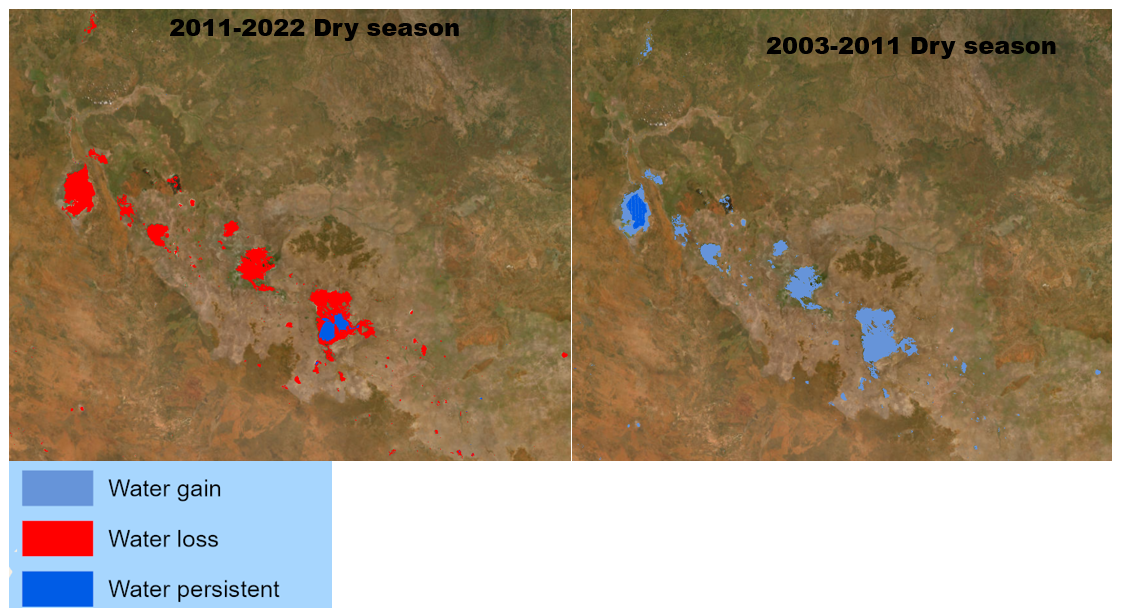
The study draws on two decades of data (2002-2022), including ground-based bore monitoring from the Bureau of Meteorology and remote sensing from multiple satellites.
Among them, NASA’s GRACE satellite - used to track groundwater depletion globally - detects subtle changes in Earth's gravity, indicating how much water has been lost underground.
“This is the first time such methods have been applied to the NT,” said lead author Dr Christopher Ndehedehe, from Griffith’s Australian Rivers Institute.
“While CLA water levels remained stable from 2002 to 2013, the research shows a steep decline in both groundwater and surface water features - such as springs and wetlands - between 2011 and 2022.
“These declines correlate with increased extraction following the approval of large irrigation licences near Mataranka in 2013, and are concerning given recent development of fracking sites in the Beetaloo Basin, which will also draw upon the aquifer.”
The research team found the aquifer was taking longer to recover from dry periods, with drought recovery times stretching from under five months in 2014 to over 15 months by 2021.
This drying trend occurred despite fewer severe droughts during the 2011-2022 period than in the previous decade.
“This research used multiple, independent sources of data, and shows that there is a serious risk of over-depletion of one of Australia's most important aquifer systems if water extraction rates continue to increase”, said co-author, Professor Matthew Currell from the Australian Rivers Institute.
“Our findings raise concerns about the sustainability of groundwater regulation in the NT amid rapidly expanding agriculture and gas developments,” Dr Ndehedehe said.
“We need improved water regulation, and our findings highlight how satellite-based monitoring can fill critical data gaps to better inform water management strategies.”
This study follows growing public scrutiny over the future of the CLA, as seen in the ABC Four Corners investigation ‘Water Grab’ (August 2025), which spotlighted risks to rivers, ecosystems, and communities with insights from the Griffith research team.
The study ‘Tracking freshwater depletion in Northern Australia: A multi-satellite approach’ has been published Ecological Informatics.

