
 Australia; NSW; QLD; WA
Expert Reaction
These comments have been collated by the Science Media Centre to provide a variety of expert perspectives on this issue. Feel free to use these quotes in your stories. Views expressed are the personal opinions of the experts named. They do not represent the views of the SMC or any other organisation unless specifically stated.
Dr Tom Mortlock is Head of Climate Analytics Asia-Pacific at Aon, and Adjunct Fellow in the Climate Change Research Centre at UNSW
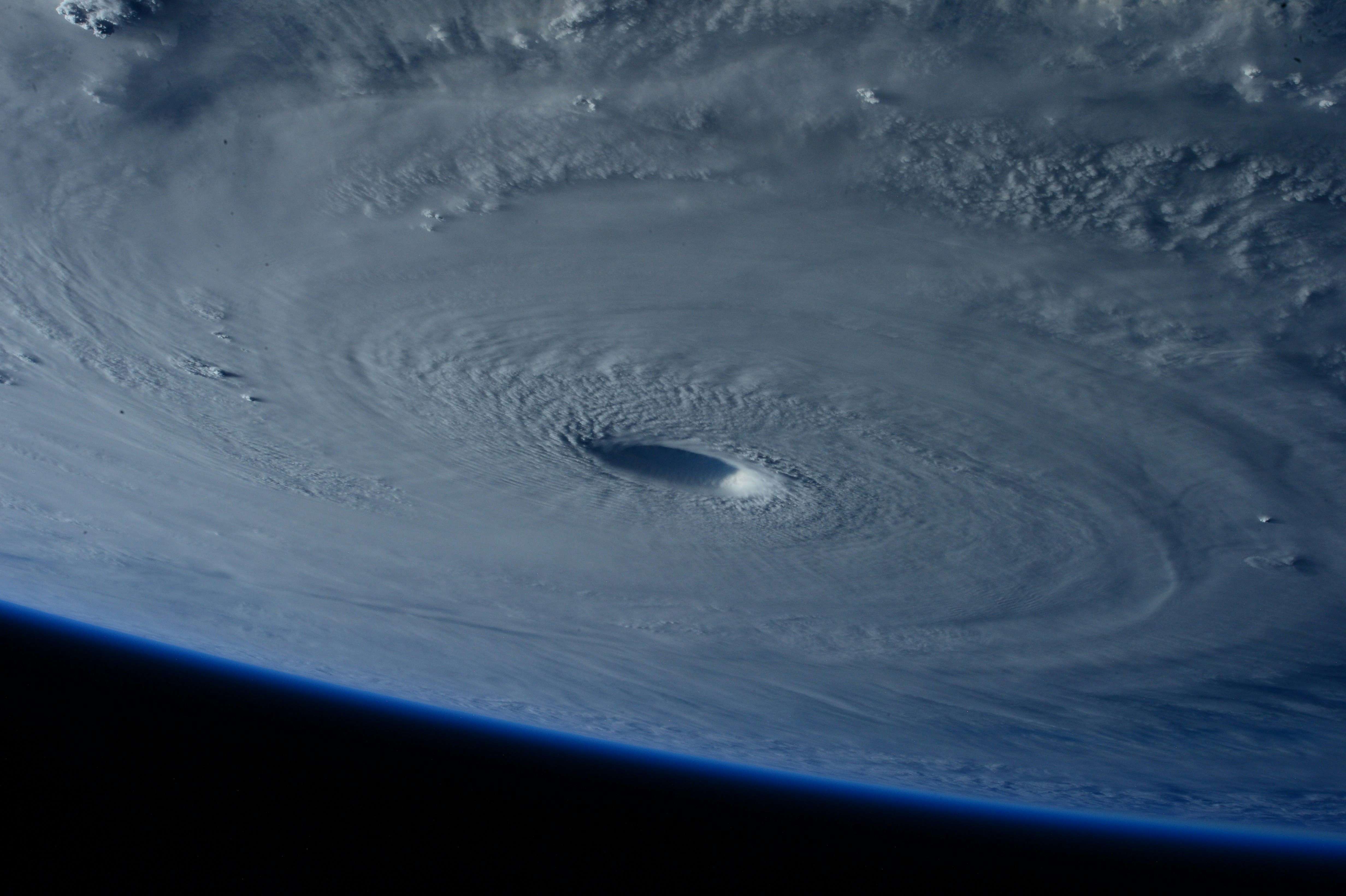
"Tropical Cyclone Narelle is an incredibly powerful cyclone expected to make landfall in Far North Queensland on Friday as a category 5 system, the most severe category on the Australian scale, with wind gusts potentially exceeding 280 km/hr.
Landfalling category five systems are relatively rare - the last time a category 5 tropical cyclone made landfall in Queensland was Severe Tropical Cyclone Marcia in 2015. Narelle’s track is very similar to the infamous 1899 'Mahina' cyclone that destroyed a whole pearling fleet in nearby Bathurst Bay and a reportedly massive storm surge of over 14 m. While Narelle is unlikely to produce a storm surge anywhere near this level, the net impact will depend on how close to high tide landfall occurs.
Narelle comes at a time when the total number of landfalling tropical cyclones around Australia has been decreasing over the past several decades. Climate models suggest that this drop in the total number of tropical cyclones is set to continue, but those that do make landfall will likely be of higher intensity – like Narelle.
One factor that influences tropical cyclone intensity is sea surface temperature. We know that the ocean has absorbed over 90% of all the Earth’s excess heat content since the 1970s, and the Coral Sea has been warming consistently for the past 40 years, with the marine heatwave of 2024 possibly the warmest the area has been in the past 400 years."

Dr Marji Puotinen is a Spatial / Ecological Data Scientist at the Australian Institute of Marine Science in the Perth office
"Cyclones can blow away your roof (Tracy 1974), make bananas very expensive (Larry 2006), destroy your boat (Debbie 2017), cause massive flooding (Yasi 2011, Jasper 2024) and even wash away your favourite beach (Alfred 2025). Luckily, severe cyclone Narelle is likely to strike land in a sparsely populated area. But did you know that extreme waves from cyclones can both smash up Australia’s coral reefs, but also cool them off from overheated ocean water?
Severe cyclone Narelle is projected to take a path through the Great Barrier Reef very similar to that of cyclone Ingrid (2005), which caused major damage to many reefs in Princess Charlotte Bay, and to do so at even higher intensity (cat 5 vs cat 4). At the same time, Narelle’s predicted path will take her right through an area of ocean that is currently experiencing heat stress.
Wave action from Narelle could bring cooler waters from deep below to beneficially cool reefs in its path. And Narelle is projected to possibly track all the way across northern Australia to Western Australia, potentially impacting reefs there. This is a rare case, having only happened five other times since 1969 (most notably cyclone Steve in 2000)."
Associate Professor Iftekhar Ahmed is from the School of Architecture and Built Environment at University of Newcastle
"As the Tropical Cyclone approaches the Queensland northern coast from the Coral Sea, it is expected to make landfall on the morning of Friday, 20 March 2026 as a Category 4 storm with powerful winds of 200-250 kilometres per hour and heavy rainfall of 200-450mm.
It is the most powerful cyclone since Cyclone Larry hit the region in 2006. Over the last two decades, incorporating the lessons from Larry, better early warning and evacuation systems are in place, and buildings are constructed to an improved wind code.
Ongoing community-based ‘door knocking’ early warning by the police and SES volunteers, and assisted evacuation by these personnel and volunteers, is a positive indicator that many people will be away from harm’s way.
People in the region are accustomed to wild weather and are also taking steps to protect their properties and assets.
However, in addition to the potential for damage by the strong winds, coastal surges and flash flooding may present additional risks, particularly to coastal properties. The flooding is expected to stretch much further south, almost to Cairns, which can affect transport and supply chains.
Queensland has very recently experienced massive floods, and while recovery is ongoing in these affected areas, another likely disaster, Narelle, will place further pressure on the state’s resources.
In the current context of an ongoing global war in the Middle East, with fuel supply constraints and high cost of commodities, the impact of Narelle could result in a complex post-disaster recovery challenge.
There is a need for a long-term and holistic recovery plan. This is a space that disaster professionals and researchers will need to keep an eye on."
