
 Australia; Pacific; NSW; VIC; QLD; ACT
News release
From:
Expert Reaction
These comments have been collated by the Science Media Centre to provide a variety of expert perspectives on this issue. Feel free to use these quotes in your stories. Views expressed are the personal opinions of the experts named. They do not represent the views of the SMC or any other organisation unless specifically stated.
Tom Worthington is an Honorary Senior Lecturer in the School of Computing at the Australian National University.
Communications will be key to relief efforts with the volcanic eruption in Tonga on Saturday. The Australian and NZ defence forces have amphibious support ships which can deliver tonnes of supplies direct to a dock, or by landing craft to outlying islands. However, there will be a need to coordinate with other nations efforts, such as China. This can't be done using the military systems Australia and NZ use for military operations, and will require an adhoc, secure network.

Emeritus Professor Ray Cas is from Monash University and an expert in volcanoes
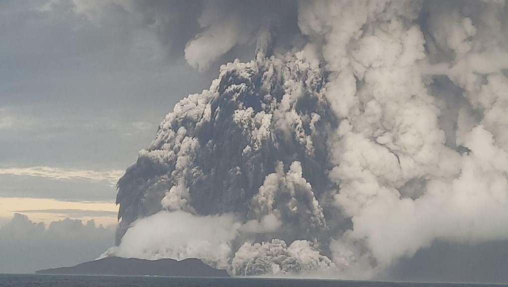
Hunga Tonga Hunga Ha'apai volcano is a marine stratovolcano in the Tongan volcanic arc that forms part of the Pacific "Ring of Fire". It has grown from the deep seafloor in the Pacific Ocean to sea level. Eruptions seem to have been recorded back in 1912, and then again in 2009 and 2014-15. The latter two eruptions were typical phreatomagmatic explosive eruptions, driven by explosive superheating of seawater by newly erupting molten rock or magma with a temperature of about 900-100oC. They were relatively small, low intensity pulsing explosive events that built a cone of ash with a central vent that linked two small islets from earlier (1912?) eruptions.
On 20th December 2021 that activity recommenced and continues spasmodically until 7th January 2022. Then again activity began on Friday 14th January. On Saturday 15th January, there was a cataclysmic explosive eruption at least 1000 times more intense than previous activity that produced a huge column of gas and ash that rose very quickly up to about 20km into the atmosphere above the vent and was spectacularly captured by weather satellites.
The intensity suggests that the explosion was driven not only by an explosive magma-water interaction, but by an increased content of dissolved volcanic gas in a new batch of magma to rise into the vent, producing an eruption that was in large part a magmatic explosive eruption.
Research by Shane Cronin at Auckland University suggests that such intense eruptions at Hunga Tonga Hunga Ha'apai volcano occur about every 1,000 years. There may be more eruptions to follow this major explosion, but probably not as intense as the Saturday eruption.
The tsunamis could have been triggered by shock waves propagating through water, but more likely largely by a landslide on the submarine part of the volcanic edifice triggered by the explosive eruption.
Dr Annie Lau is a Lecturer in the School of Earth and Environmental Sciences at The University of Queensland
The eruption of Hunga Tonga-Hunga Ha’apai volcano in Tonga on Saturday has generated a Pacific-wide tsunami. We saw reports and videos from Fiji that the sea had retreated before the tsunami wave arrived, and later gushed onto shore. It coincided with a falling tide in Fiji so the waves did not hit higher ground. Still, coastal villages in low-lying areas were inundated by high waves and strong currents. The tsunami arrived at the eastern Pacific when the tide level was high, causing coastal floods in multiple countries. We have reports from Chile describing that the tsunami travelled upstream to at least several hundred meters from the river mouth.
Tectonic plates are moving at very high speed near Tonga, making it a seismic active region. The Pacific plate is moving west at 16-24 cm/year, subducting beneath the Tonga plate. This plate subduction creates numerous volcanoes. Although no large tsunami has occurred in Tonga in recorded history, there are large isolated limestone boulders sitting 10 m above sea level on Tongatapu that serve as evidence of high wave inundation in ancient times.
Tsunami simulations done by researchers showed a large tsunami with wave height over 10m was needed to generate enough energy to lift and transport those huge rocks. That ancient tsunami could have been triggered by an volcanic eruption, a volcanic flack collapse, or/and a submarine landslide. Geological evidence like this shows us the tsunami on Saturday was not the first large tsunami to impact Tonga.
Dr Andrew Tupper is Principal Consultant at Natural Hazards Consulting. He was previously manager of the Darwin Volcanic Ash Advisory Centre, and co-director of Australia’s Joint Australian Tsunami Warning Centre
Satellite data from NASA confirms that the eruption reached at least 30 kilometres in altitude on Saturday. This is one of the highest eruption clouds to have been observed on satellite, although lower than the maximum 40 kilometres estimated from the larger Pinatubo eruption in 1991. At the moment, the stratospheric portion of the cloud is being tracked by MetService NZ and the Australian Bureau of Meteorology and is located over north-east Australia, drifting westwards. The cloud base is well higher than the heights aviation normally fly at.
Eruptions such as this one help reinforce the need for global cooperation on hazards of all kinds. The eruption produced ash, gas, acid rain, tsunami and more. The tsunami wave heights were partially tracked through tide gauges that Australia has supported in the Pacific, and the atmospheric clouds through satellite data operated and shared by Japan and others. Our cooperation as a global community helps us all manage these events, including the impacted countries. But there’s lots more to do as we work to manage natural hazard together better globally.
Dr Heather Handley is Volcanologist and Associate Professor at the University of Twente and Adjunct Associate Professor at Monash University
On Saturday a large eruption occurred at the submarine Hunga-Tonga-Hunga-Ha'apai volcano in the Kingdom of Tonga. The effects of the eruption were felt all around the world, with the associated shockwave and tsunami reported as far away as Alaska.
The main body of the massive underwater volcano stands around 1800 metres above the seafloor and is 20 kilometres wide. The caldera of the volcano stretches six kilometres across and is 150 metres deep. Recent volcanic activity in 2014-2015 built a ~100 metre high volcanic cone above the water surface joining the small islands of Hunga-Tonga and Hunga-Ha'apa (products of older eruptions at the volcano). A satellite image taken of the volcano, just two hours before Saturday's eruption, shows that the 2014-2015 cone had been largely destroyed in the days before Saturday's eruption.
The volcano has been frequently active in historic time with records of past eruptions in 1912, 1937, 1988, 2009 and 2014-2015. Past volcanic research on the volcano suggests that large-scale eruptions might occur around every thousand years at the volcano.
The ash and gas plume from Saturday's eruption reached the stratosphere. Present estimates indicate that the plume reached 30 kilometres high, making it a very powerful eruption. The official magnitude of the eruption has yet to be finalised and is usually determined after the eruption period ends.
Volcanologists use the Volcanic Explosivity Index to describe the magnitude of volcanic eruptions. Where a VEI of 8 would be a 'supervolcanic' eruption and VEI 0 eruption would be something like a gently oozing lava flow. Assignment of VEI is based mainly upon the height of the ash plume, injection of material into the stratosphere and the amount of material erupted during the eruption. The underwater eruption in a marine setting may make it more challenging to estimate the amount of material erupted.
The volcano is located in the Tonga-Kermadec volcanic arc and part of the so called "Pacific Ring of Fire". Here at the plate boundary the Pacific Plate is being pushed down and under the Indo-Australian Plate. The downgoing plate heats up as it descends and starts to 'sweat'. This releases fluids into the overlying mantle and causes it to melt. The fluid-rich magma then rises to the surface to form a volcano and the fluids involved in the formation of the magma, form gas bubbles at shallower levels in the crust and fuel explosive eruptions in these tectonic settings. It's unclear at this stage whether influx of seawater into the vent added to the explosiveness of the eruption.
It's unclear whether the volcano will produce another large scale eruption or activity will decline but volcanic activity is likely to continue over the coming days.
Hannah Power is an Associate Professor in Coastal and Marine Science at the University of Newcastle
The eruption of the submarine volcano Hunga Tonga Hunga Ha'apai generated a tsunami that has been felt across the whole of the Pacific Ocean.
The sea level gauge at Nuku’alofa, Tonga, recorded a tsunami wave of 1.19m before it stopped reporting. Waves of over 1m were also observed in Vanuatu and Norfolk Island, Australia, and as far afield as Chile. Waves of over 50cm were measured in several locations in New South Wales, Queensland, Fiji, the Cook Islands, New Caledonia, and New Zealand. Across the Pacific, tsunami waves were observed along both the North and South American coastlines and in Japan.
Before communications were lost, video reports showed significant tsunami wave flooding and inundation occurring in Tonga which has caused damage to roads, buildings, and infrastructure such as seawalls.
Flooding and localised inundation have been reported in Fiji, Chile, Ecuador, and the USA.
We are still seeing small but measurable waves in Australia as a result of this tsunami.
Given the potential for further volcanic activity, there is also the potential for further tsunami to be generated. Communities should keep a close eye on emergency alert services and follow all guidance from emergency services.
Andrew Gissing is General Manager of Resilience at Risk Frontiers. He led tsunami planning in NSW and VIC and was involved in the development of the Australian Tsunami Warning System following the Boxing Day tsunami.
A series of tsunami waves resulting from the Hunga Tonga-Hunga Ha'apai eruption have resulted in tsunami impacts across the Pacific Ocean and have been observed on the Australian east coast. Thankfully no major impacts have been reported here.
Some five per cent of all historic tsunami globally have been produced by volcanos. An example was the Krakatoa event in Indonesia in 1883 that resulted in tsunami impacts across the Indian Ocean.
Small tsunami are not an unusual feature along the Australian east coast with over 50 reported since European settlement. The most notable of these events occurred in 1960 resulting from the magnitude 9.5 earthquake offshore of Chile, which is the largest recorded earthquake in the world. Observations of the tsunami included rapidly oscillating water levels in bays and harbours and grounding of some boats and minor inundation of foreshores. Other similar events also originating from South America occurred in 1868 and 1877.
There is a risk of a major tsunami posing a land-based threat to the east coast in the future, though the likelihood should be considered rare. It could originate from a large undersea earthquake in the South Pacific Ocean.
Significant advances in tsunami warning and planning capability have occurred since the devastating Indian Ocean tsunami in 2004, including the development of the Australian Tsunami Warning System operated jointly by the Bureau of Meteorology and Geoscience Australia.
More effort is required though to improve community understanding of tsunami risk both in Australia and elsewhere.
More information can be found at: riskfrontiers.com/insights/hunga-tonga-hunga-haapai-eruption-15th-of-january-2022/
Dr Chris Firth is a volcanologist
The eruption of Hunga Tonga-Hunga Ha'apai volcano in Tonga over the weekend was one of the world's biggest volcanic eruptions since the early 1990s. The bulk of the volcano was underwater, although a small volcanic island appears to have been destroyed during the eruption. Luckily, this island was remote and uninhabited, otherwise casualties would have been much higher.
Nevertheless, the size of the eruption means impacts have been felt widely across the Pacific. Tsunamis generated by the shock wave from the eruption radiated across the Pacific Ocean reaching as far away as California and Japan. The impact of tsunamis would have been most significant in Tonga itself. Tsunamis travel at speeds of hundreds of km/hr, so local areas would have had little warning, while also being impacted by the most powerful waves.
The other major concern is ash-fall, with potentially centimetres of ash falling on neighbouring islands. This ash covers buildings and infrastructure making recovery difficult, buries gardens and impacts plants with consequences for food supply, and is likely to contaminate water supplies. Ash is also hampering rescue and relief efforts as aircraft cannot fly through it.
The volcano appears to have quietened for now, however eruptions of this magnitude are not usually over so quickly and the volcano may continue to be active over coming weeks or months.
Professor Martin Van Kranendonk is director of the Australian Centre for Astrobiology based at UNSW Sydney.
Volcanoes are a part of the natural world and provide many of the essential nutrients that support life on Earth. They are violent and unpredictable, but we have to learn to adapt to their presence, as humanity has to do throughout the history of mankind. Nations that live on volcanoes must have emergency plans in place, as they can erupt at any time. Given the scale of eruption events, this may need to include arrangements with international partners. The effects of eruptions can include earthquake damage, flooding from tsunamis, toxic gases, and ash and other fallout deposits from an eruption event.
