
 Australia; NSW; WA
Expert Reaction
These comments have been collated by the Science Media Centre to provide a variety of expert perspectives on this issue. Feel free to use these quotes in your stories. Views expressed are the personal opinions of the experts named. They do not represent the views of the SMC or any other organisation unless specifically stated.
Emeritus Professor Roger Stone is a Professor Emeritus in Climate Science at the University of Southern Queensland
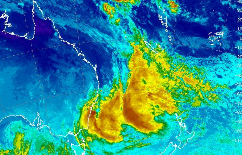
Well, it's 'simply’ an East Coast Low.
Cold core, low pressure systems are often referred to as ‘cyclones’ in meteorological circles (but not as ‘tropical cyclones’ – which have a warm core). These sorts of ‘cold core cyclones’ are quite common in places such as the North Sea, between the UK and Germany.
East Coast Lows are quite common at this time of year off the NSW coast, and form when upper troughs and strong jet streams coexist in the upper atmosphere. The sea-surface temperatures this year are also warmer than normal (for this time of year) – again, nothing unusual about that.
If synoptic conditions further favour it, a deep surface low pressure system can then develop – usually somewhere between K’gari and Sydney. They can sometimes be quite strong.

Associate Professor Andrew Dowdy is from the University of Melbourne
A 'bomb cyclone' is a low-pressure system outside the tropics that intensifies very rapidly, based on how fast the atmospheric pressure drops at the centre of the storm. It is typically defined as a pressure drop of 24 hectopascals (hPa) over 24 hours.
The current storm could be called an east coast low, consistent with this definition: 'East coast lows are cyclones near southeastern Australia that can be caused by both mid-latitude and tropical influences over a range of levels in the atmosphere.'
The storm has a large low pressure centre over a range of heights through the atmosphere, including up to about 5 km high above the ground, as is typical of many east coast lows that have caused severe impacts in the past.
The current storm is being described by some in the media as a 'vigorous low pressure system', which is useful to help communicate to the general public that there is potential for dangerous conditions, while noting that a 'vigorous low' is not a technical term to describe a specific storm type.
Underneath the low pressure system around 5 km above the surface, there is forecast to be two lows near the surface that spiral around each other, which is known as the Fujiwhara Effect. The forecasts are generally good for predicting the large-scale features many days ahead, but a challenge with the forecast for this current storm could relate to the two lows near the surface. This is because the interactions between two cyclones close to each other like this can be hard to predict with high accuracy. It is very rare to see two east coast lows spiralling around each other like this.
Low pressure systems include tropical cyclones in northern regions, that can sometimes also impact the subtropics such as recently occurred for Tropical Cyclone Alfred, as well as extratropical cyclones in southern regions from Tasmania up to southeast QLD. In general, tropical cyclones get energy from warm ocean waters, whereas extratropical cyclones get energy from temperature and pressure variations in the air, with hybrid cyclones having characteristics of both tropical and extratropical cyclones.
The current system is predicted to be large and deep (noting the cyclone extends from about 5 km high down to the surface). Deep cyclones like this are more likely to cause severe impacts, such as extreme rain and winds, as compared to shallow cyclones that don't extend over this range of heights through the atmosphere. Additionally, the current system is slow moving, staying close to the coast for a couple of days before moving away to the east, which can contribute to large accumulations of rain in some regions for potential flood risks (e.g., rain totals around 100-200 mm or more predicted for some regions). The damaging winds tend to occur on the south side of east coast lows. In addition to the damaging extreme winds and rain, there are also likely to be extreme waves causing coastal hazards and impacts.A 'bomb cyclone' is a low-pressure system outside the tropics that intensifies very rapidly, based on how fast the atmospheric pressure drops at the centre of the storm. It is typically defined as a pressure drop of 24 hectopascals (hPa) over 24 hours.
Milton Speer is a Visiting Fellow in the School of Mathematical and Physical Sciences at the University of Technology Sydney
This east coast low was not going to be a major event initially on the Mid-North coast or Hunter coast because the upper level trough is embedded in the westerlies over southeast Australia. The surface low-pressure system is developing east of Newcastle/Sydney, concentrating the rain from Newcastle to Wollongong.
When the surface low is more fully developed east of the coast overnight/tomorrow morning under the upper trough, dumb-belling of the surface low is likely to send it closer to the Central and Hunter coasts, returning rain and strong winds to those areas. Dumb-belling occurs when the upper circulation in the low-pressure trough directs the movement of the surface low also in a circular motion.
Research shows that global warming in recent decades has caused east coast lows to form further poleward and further east of the coast.
Associate Professor Iftekhar Ahmed is from the School of Architecture and Built Environment at University of Newcastle
A low-pressure system has been brewing in the ocean for a week or so as noted by the Bureau of Meteorology, leading to the current warnings. It is usually possible to predict the landfall of cyclones in advance.
NSW is being impacted by a series of hydrometeorological hazards, including Cyclone Alfred last March, and the recent Central Coast flooding, the largest flood event in recent history. And now the East Coast is facing what has been termed a "bomb cyclone".
This 'bomb' event is expected to be intense and peak with a large volume of rainfall and very strong gusts within a short span of time, hence the name. At an expected 125 kilometres per hour, this would be equivalent to a Category 3 cyclone.
In terms of community preparedness, warnings have been widely and repeatedly issued on different media, so it can be expected that people will be cautious and take the necessary risk reduction measures. The SES has also stepped up with many active volunteers and has already responded to a number of calls for help.
However, there is a high risk to coastal properties and assets, and particularly, coastlines facing possible erosion. Some of these areas, Wamberal and Stockton beaches, for example, are already experiencing erosion, and it is necessary to be prepared for the impact of this event. In addition to flash floods, there is also the risk of some riverine flooding, in catchments such as those of the Hawkesbury and Nepean rivers in one of the floodplains in Australia most at risk of flooding.
To state simply, cyclones occur due to convection currents generated due to a warm ocean. The United Nations Office for Disaster Risk Reduction (UNDRR) has recently reported on the warming of oceans globally due to climate change and consequent cyclonic activity. We therefore need to go beyond the response and recovery efforts and understand the root causes of such intense events.
The focus at the moment is on emergency management. The region has experienced recent floods earlier this year, and recovery is still ongoing, so this event will add to the challenges. There is a need for a long-term recovery plan that should be activated before the event impacts so that organisations and communities can hit the ground running soon after the event has passed.
Dr Elizabeth Jackson is a Senior Lecturer in Supply Chain Management and Logistics at Curtin University
Consumers and businesses, particularly in the regions, may face shortages of essentials like food and fuel. This bomb cyclone is likely to have severe impacts on transport networks, which means staff getting to work, the ability to move goods from point of production to distribution centres and retailers, and delays over the next few days and weeks from backlogs.
When the cyclone has subsided, transport networks may face damages that mean lengthy detours for road transporters. Catastrophic weather events are becoming more frequent and more ferocious so, in order to manage the impact on society, more resilient transport networks need to be created, and retailers need to move away from centralised distribution systems so we’re not so reliant on complex, long distance freight systems.
Mr Andrew Gissing is the CEO at Natural Hazards Research Australia
The current heavy rain impacting the NSW coast is likely to result in flash flooding, where floodwaters can rise rapidly.
Flash flooding is dangerous, particularly to motorists, as illustrated in recent flooding on the NSW Mid North Coast. Driving through floodwater is a leading cause of flood fatalities, though research shows that many motorists often attempt to cross flooded roads. People should not walk, drive or play in floodwater.
Previous research has found that 84% of motorists ignore road closure signs. Those who are most likely to enter floodwater are younger men, those who work outdoors and drivers of 4WDs. Only a small error in judgement can be fatal. Floodwater might be deeper or faster flowing than expected, the road may be washed away underneath, or conditions could rapidly change.
Dr Martin Jucker is a lecturer at the University of New South Wales and Associate Investigator at the ARC Centre of Excellence for Climate Extremes
This is an extreme weather event unlike what we usually experience: It develops fast and right next to the coast, bringing heavy rainfall and strong winds - hence the 'bomb' attribute. Although it might not satisfy all of the required conditions for a Named Storm or an East Coast Low, it may be just as impactful given its intensity and how it tracks along the coast.
While to me it is not clear what role climate change might play in the occurrence and evolution of such cyclones, it seems safe to say that the current very high water temperatures off the eastern Australian coast would help such systems to become intense by providing the necessary moisture from the warm ocean surface. While lows along the east coast are by no means a new phenomenon, we still don’t really understand why such systems stay close to the coast for a long time, and why some of these systems move very slowly or even stall at one given location. As noted by the NSW 2022 Flood Inquiry, more research needs to be done to understand these weather events, and to be able to estimate their behaviour in the future.
