New Zealand
News release
From:
El Niño declared, expected to intensify into one of the strongest on record
Earth Sciences New Zealand has confirmed that El Niño conditions have been reached in the tropical Pacific and are expected to strongly influence New Zealand’s weather into 2027.
El Niño is a global phenomenon, originating with the warming of ocean temperatures in the eastern and central equatorial Pacific. Historically this has resulted in a New Zealand spring dominated by westerly quarter winds (southwest to northwest), typically bringing drier than usual conditions for eastern and northern areas of both islands and wetter than usual conditions for the western and lower South Island.
“Observations of sea surface temperatures in the east-central tropical Pacific show the hallmarks of a historically strong event, which is also echoed by the modelling,” says Chris Brandolino, Earth Sciences New Zealand Chief Scientist Weather and Seasonal Forecasting.
A sea surface temperature (SST) difference from average, known as an ‘anomaly’, of 1.5°C is a marker of a ‘strong’ El Niño; if the anomaly reaches at least 2.0°C that’s considered very strong, sometimes termed a ‘super’ El Niño. The top five strongest El Niño events (1972, 1982, 1991, 1997, 2015) all had SST anomalies near or slightly above 2.5°C. The SST anomaly recorded for this event has already exceeded 1.0°C and will continue to increase.
“At the very least we’re expecting this event to rival the intensity of these historical top five events, but it has considerable potential to exceed them all,” says Brandolino.
Likely impacts on New Zealand’s weather this spring Earth Sciences New Zealand and MetService meteorologist Jon Tunster says it is important to recognise that New Zealand’s weather is influenced by many factors. These include the Indian Ocean Dipole (shifting ocean temperatures in the Indian Ocean), regional SSTs, occasional influences from Antarctica, and climate change.
“There’s more to it than El Niño, or even Super El Niño, but this El Niño event is shaping up to have a major influence, potentially from September onwards.”
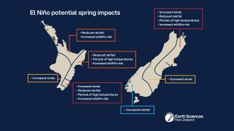
“As we’ve seen with the previous El Niño events, the overwhelming majority of long-range models are favouring drier than usual conditions for northern and eastern areas of New Zealand, while western regions – especially of the South Island – are likely to see increased rainfall.”
“The combination of wind and reduced rainfall will dry soils, and lead to periods of increased wildfire danger – especially when temperatures are elevated and humidity is low. These conditions are most likely to occur on the eastern, and perhaps northern, sides of the country,” says Tunster.
“The prospect of lower rainfall in several regions is likely to result in reduced groundwater recharge, creating challenges for water-reliant sectors.”
What to expect over the next three months
Weather patterns ahead of spring are likely to be mixed. For example, a significant rain event is expected within the first 10 days of July, likely affecting eastern areas of both islands. However, over the longer- term, these same areas are expected to see a decrease in rainfall as westerly winds begin to dominate.
The Earth Sciences New Zealand Seasonal Climate Outlook for July to September forecasts:
- An eventual lean towards drier than usual conditions for Canterbury, Marlborough, eastern Otago,
Wairarapa, and from Hawke’s Bay to Gisborne. - Drier than normal conditions for Taranaki to Bay of Plenty through to Auckland and Northland.
- Wetter than usual conditions for Westland through to Southland, perhaps extending into parts of
Central Otago. - Windier than usual conditions for much of the country from late winter into spring.
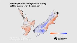
Patterns and variation in how past El Niño events have played out
Comparison of the top five historical El Niño events clearly indicates the recurring pattern of an unusually dry spring in the north and east, and wetter in the south and west. These dry conditions were particularly pronounced in parts of Canterbury in all five events, with only two thirds of normal rainfall for the period of July to September.
“It’s important to bear in mind that while we know the average outcome of El Niño because of historical data, no El Niño is average—each comes with a unique set of climate characteristics and therefore can be expected to influence the weather differently,” says Brandolino.
Subtle differences in wind direction can affect temperature and strongly inform rainfall patterns, and there are examples of notable variation across the five historical events.
“In 2015, springtime weather patterns favoured an increase in southwesterly and southerly flows, whereas 1972 saw more high-pressure systems near the North Island, bringing increased northwesterlies across the South Island. As a result, spring of 2015 was almost a full degree cooler than 1972, which is especially notable given that the background climate has warmed over that same period,” says Tunster.
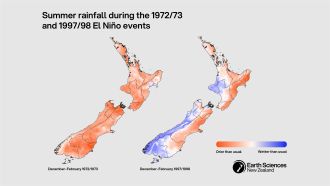
The impact of small differences in wind direction is also evident when comparing summer rainfall from 1972/73 with 1997/98.
“We saw nationwide dryness in the earlier event, and more regionally confined dryness in the latter,” says Tunster.
Strong El Niño events can influence weather patterns across multiple seasons. Earth Sciences New Zealand will continue to provide further updates through our monthly Seasonal Climate Outlook as this event develops.
Expert Reaction
These comments have been collated by the Science Media Centre to provide a variety of expert perspectives on this issue. Feel free to use these quotes in your stories. Views expressed are the personal opinions of the experts named. They do not represent the views of the SMC or any other organisation unless specifically stated.
Professor Anita Wreford, applied economist, Lincoln University
"The declared El Niño conditions could have important implications for Aotearoa NZ’s agricultural sector and the wider economy. Typically El Niño conditions have led to droughts in the eastern parts of the country – the impact of these will depend on how long they last and how widespread across the country they are. Drought conditions negatively affect agricultural production, often requiring supplementary feed to be purchased, the culling of stock and potential tension between different users of water.
"Previous El Niño events have led to a reduction of 0.4% of GDP after four quarters 1 (following a relatively standard El Niño event, not an intense one like this one may be). In context, Aotearoa’s real GDP grew by 0.2% over the 2025 calendar year, so the impact is not insignificant.
"The financial impact depends also on whether and how El Niño presents globally, as Aotearoa is highly connected globally through trade. If other agricultural producing countries are negatively affected, this could reduce global supply and result in higher global prices for commodities such as dairy. This would soften the impact for our producers, but consumers would end up paying more for affected food items. In addition, if El Niño affects the supply of some of our imported feeds, these prices will also increase, affecting our livestock producers.
"Direct impacts on the agricultural sector flow into other areas of the economy, including processing, transport, business and the regional economies. If reduced rainfall in key areas affects hydropower storage, electricity prices will increase and affect all users of electricity. Wildfire risk would also increase, particularly as strong winds are expected alongside drier conditions.
"The impacts are currently uncertain, but exposed sectors can reduce the risk by having robust and flexible plans to adjust their practices as the impacts unfold."

Professor Cate Macinnis-Ng, School of Biological Sciences, University of Auckland
"From a biodiversity perspective, the likely drier spring conditions across much of the country can bring mixed impacts. If dry conditions continue for several months, especially if they remain into the warmer summer months, trees, other plants and animals will start to suffer water stress. This can reduce plant productivity, reducing carbon uptake. As drying ground hardens, kiwi are unable to penetrate the soil to access their food. Similarly, mudfish suffer during dry summers as the forest pools they live in dry up quickly.
"However, there can be some early positive effects. The strong relationship between El Niño conditions and growth of kauri trees is well known. Analysis of tree-rings of kauri indicates wider rings during dry springs associated with past El Niño events. This is possibly because the trees are more productive when there is less cloud cover but the physiological mechanism behind the growth has not been fully explored.
"Overall, the longer a drought lasts, the worse the impacts will be and when drought coincides with warmer and drier air, drought impacts will also be worsened. High winds are likely to bring down branches and topple trees, potentially creating fuel for fires. Drier vegetation (dead or alive) becomes more flammable, and together with warm and windy conditions, these factors all further increase fire risk. In parts of the country where rain will increase, biodiversity will suffer from the impacts of flooding and land slides which can be equally damaging as the impacts of dry conditions.
"The seasonal climate outlook released by Earth Sciences New Zealand emphasises the complexity of weather during coming months. It will be interesting to see how the coming seasons play out and understand that if the worst scenarios don't occur this summer, they are our new reality. While El Niño conditions are a natural part of the weather cycle, extreme events are being intensified by climate change. We desperately need to better prepare for these extremes rather than responding to crises as they happen."
Shana Gross, Fire Ecologist, Bioeconomy Science Institute
"Wildfires occur across all phases of El Niño Southern Oscillation (ENSO), but the phase alone does not mean there will be a greater number of fires or greater number of areas burnt. None of the years identified as strong El Nino events (1991, 1997, and 2015) have particularly high area burnt or number of wildfires. However, the year following 1997 (1998/1999 fire year) was the worst on record for area burnt.
"An important caveat is that El Nino is also the most infrequent phase of ENSO. Between 2000-2020 there have been fewer fires and less area burnt during El Nino, but it has also been the most infrequent phase.
"The weather is what we need to focus on. Fire weather can occur during any of the phases. Key things to be aware of are dry conditions where fuels can ignite and high winds where fire can spread. So, where El Nino brings dry and windy conditions, fire hazard will increase. During these periods it is critical for the people to be aware of heightened fire danger and be cautious with activities to avoid ignitions. Wildfires will happen if ignitions happen."
Veronica Clifford, Senior Technologist in the Wildfire Research Team, Bioeconomy Science Institute
"With the prediction of a strong El Nino appearing in the horizon, a helpful guide is this monthly fire seasonal severity poster, where you can get a rough idea of how things panned out across the country for each of the past El Niño Southern Oscillation (ENSO) phases during our fire seasons.
"Under El Niño there are increased odds for severe fire danger in regions that experience conditions that are warm, windy, and drier than usual. Those regions are generally located in the north and east of both islands.
"To help understand what the upcoming fire season could look like, recent past events reminiscent of a strong El Niño included 2015/16, 2009/10, 1997/98 and 1991/92. These years are potentially good indicators for what to expect this coming fire season.
"We can clearly see from significant historical El Niño events that no two El Niño’s produce the same outcomes. In general, under El Niño, there is an increased likelihood of elevated fire danger in the north and eastern regions of both islands (you can see the hotspots in the red areas). The effects of a strong El Niño can be seen as early as November and can linger into March/April. This warrants early fire risk management discussions and actions by landowners and managers whose livelihoods are likely to be affected by prolonged dry, warm, windy conditions generated by El Niño events."
Dr Helen Rutter, Senior Hydrogeologist, Lincoln Agritech
"Water makes its way into the groundwater system mainly during the winter when temperatures are lower, plant growth is limited, and any rainfall may infiltrate through the soil and not be used up by plants. The report suggests that below-normal winter rainfall in several regions (if it occurs) may mean we get below normal groundwater recharge, and this could become an issue for people who use groundwater for drinking water, irrigation or other uses.
"The implications of low recharge this winter will depend on how healthy the groundwater reserves are currently. Groundwater levels vary with season, and from year to year. Where groundwater levels are already low, if there is reduced winter recharge, then this could affect people's ability to abstract groundwater, though the effects may not be felt until next summer. If groundwater levels are currently high, then the effects of a low recharge winter are usually not as severe in terms of being able to access and use groundwater.
"It is important to note the caveats stated: the report assesses the likelihood of climate conditions being at, above, or below average for the season as a whole and are not ‘weather forecasts’. (It is not possible to forecast precise weather conditions three months in advance). Additionally, they are the result of expert judgment of scientists and forecasters. The forecasts are not actual impacts in terms of local weather through the winter, which will only be known as they eventuate."
Troy Baisden, co-President of the New Zealand Association of Scientists and Adjunct Professor at Victoria University of Wellington
"Earth system models have settled on consistent indications that this will very likely be the strongest El Nino ever – so much so that historical understanding of strong El Nino effects may not be predictive for this year. These are exactly the conditions where it would have been desirable to have the strength of modelling and assessment teams for our unique corner of the Earth that were defunded and dispersed recently, by the end of support including the Deep South Challenge (see here for more details)."
Multimedia