
 Australia; NSW
News release
From:
Expert Reaction
These comments have been collated by the Science Media Centre to provide a variety of expert perspectives on this issue. Feel free to use these quotes in your stories. Views expressed are the personal opinions of the experts named. They do not represent the views of the SMC or any other organisation unless specifically stated.
Dr Behzad Fatahi is Professor of Civil Engineering at the University of Technology Sydney
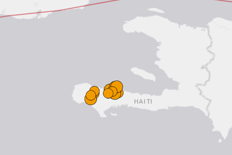
At 8:29am local Haiti time (i.e. 12:29 Coordinated Universal Time UTC) on 14 August 2021, a magnitude 7.2 earthquake at a very shallow depth of 10 km occurred about 13 km south east of Petit Trou de Nippes city (population of 36,000) and 150 km west of the capital Port-au-Prince, in western Haiti.
The intensity of this earthquake, which was IX (known as a violent earthquake) indicates that unfortunately heavy damage to structures, buildings and infrastructure will be expected and the peak ground velocities and accelerations in excess of 85 cm/s and 0.7g are expected, respectively.
The energy released due to this earthquake was twice of the 2010 Haiti earthquake.
Within the past 24 hours, 17 aftershocks with magnitudes between 4.0 and 5.8 have been recorded in the same region in the vicinity of major cities of Pestel, Aquin and Petit Trou de Nippes.
While epicentres of two aftershocks with magnitudes 5+ were reported to be offshore, no Tsunami due to the main earthquake is expected.
In this region and about 200 km to the north of this earthquake, two major Caribbean and North American plates slide past each other at a velocity of about 20 mm/year as a part of the Cayman trench, which is the deepest point in the Caribbean Sea.
From a more localised view, the Gonâve microplate interacts with the rest of the Caribbean plate via the Enriquillo fault, which passes through the southern section of Haiti, which is believed to be the main source of this recent 7.2 magnitude earthquake and the 2010 Haiti earthquake that claimed over 150,000 lives.
It is estimated that about 37 km of the Enriquillo fault has been ruptured due to this recent earthquake.
The vast majority of the ground in the southern part of Haiti near the earthquake-affected area is covered by limestone which is a sedimentary rock made of calcium carbonate (CaCO3).
However, there are regions such as Les Cayes city (population in excess of 86,000) and Jacmel city (population in excess of 137,000) sitting on alluvium, which is composed of loosely compacted mixture of clay, silt, sand and gravel.
The presence of the alluvial deposit can amplify the seismic shaking arriving on the ground surface, while soil liquefaction is also expected in loose sand and silty deposits. Indeed, the 1985 Mexico City earthquake with a death toll of over 10,000 people, clearly highlighted the impact of the presence of soft clay deposits on earthquake amplification.
It is foreseen that the 14 Aug 2021 Haiti earthquake has created significant and widespread slope failures, landslides and liquefaction, severely impacting more than 50,000 people. Considering the geology and population distribution, it is expected that most of the damage has occurred in the southern and western parts of Haiti, particularly Les Cayes, Jeremie and Baradères.
What is particularly concerning in this area is the potential for liquefaction. Considering the presence of alluvial deposits composed of saturated sands and silts, in the vicinity of towns of Anse-a-Veau, Camp-Perrin and Les Cayes and many other villages in the middle, large ground settlements, and buildings and roads sinking into the ground as a consequence of ground liquefaction are very likely.
Local roads and bridges can be damaged directly due to the earthquake or due to landslides, rock falls and liquefaction. This can hamper the search and rescue efforts and obstruct access to the affected areas needing urgent attention particularly near villages and towns close to the epicentre.
Reviewing the geology and topography of the area shows that roads and highways going out of Les Cayes and particularly connecting to Jeremie are the most susceptible to landslides.
Assessing information coming through the region shows that unreinforced masonry structures, concrete structures with slender columns and inadequate steel reinforcement supporting heavy slabs, and structures with weak foundation have collapsed or severely tilted and damaged.
Residents must stay away from the cracked building as aftershocks can further loosen the already compromised structures and result in total collapse. Residents should also stay away from temporary excavations particularly near existing buildings.

